Irish Overall Site Rankings

The first Irish site rankings for grassland fungi appeared in the paper  “The Fungi of Irish Grasslands and their value for nature conservation” by Roland McHugh, David Mitchel, Mark Wright and Roy Anderson in Biology and Environment, Vol 101B, No.3, 225-242 (2001). These webpages will offer the most up to date site rankings and species lists of Irish grassland fungi.

See the Atlas for more details on the distribution of these species in Northern Ireland or the Photo Gallery for images of these species.

This is the most up to date ranking of Irish sites ranked by number of waxcaps – H (last updated 24/03/2026). You can click on the site name to view the record list so if you find new species for these sites, please record them on the CEDaR grassland recording page.

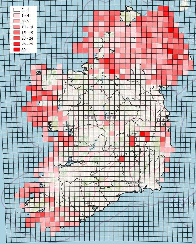
You can also view the sites on a map here.

SiteCountyCHEGDNoVisits
The CurraghKildare1337345435
Clare IslandWest Mayo52976217
Slievenacloy ASSIAntrim82896123
Knock Dhu and Sallagh Braes ASSIAntrim92787116
Killykeeghan and Crossmurrin NNRFermanagh52655114
Rathlin Island: Kebble ASSIAntrim826105124
Binevenagh ASSILondonderry1125178119
Galboly ASSIAntrim1025126110
Divis and Black MountainAntrim82464118
Monawilkin ASSIFermanagh42410538
Ballyprior CommonageLaois4239226
Legland MountainFermanagh4236204
Barnett’s ParkAntrim52243143
Fair Head and Murlough Bay ASSIAntrim822106117
Ballygalley Head ASSIAntrim7218514
Cushleake MountainAntrim5215603
GortnagoryAntrim4211214
Marlbank ASSI: BrookfieldFermanagh6216625
Rathlin Island: Roonivoolin RSPB reserveAntrim6217117
Stormont EstateDown62163162
Achill Island: Keem BayWest Mayo3206413
Dursey IslandWest Cork62012214
Glendun Hill Farm UWT ReserveAntrim5202105
InishsharkWest Galway3203101
Rathlin Island: Knockans RSPB ReserveAntrim4208014
Rowallane GardensDown42000123
Agnew’s HillAntrim3192304
Arran MoreWest Donegal5196111
Clonmantagh HillKilkenny31910315
Divis: Fraser’s FarmAntrim5193001
Linford Barrows Earth RingsAntrim9193619
Marlbank ASSI: Gortmaconnell RockFermanagh4194515
AghadachorWest Donegal61813112
Ballycastle Coalfield ASSIAntrim3182103
Ballycoos HillAntrim8183617
Giant’s CausewayAntrim3186119
Great Heath of MaryboroughLaois4184203
Hillsborough Parish ChurchDown5180309
Longmore HillAntrim2180211
Mount Stewart Estate (NT)Down81851136
Murlough NNRDown51844131
Rathlin Island: Craigmacagan RSPB reserveAntrim4188112
Silent ValleyDown51884110
Tievebulliagh MountainAntrim5181101
Ballyclare: Five Corners: Rashee CemeteryAntrim4171103
BallynacarrigaWest Cork5177111
Bantry HouseWest Cork7172021
InishbofinWest Galway4174101
Knockmore HillFermanagh1176208
Murrevagh MachairWest Mayo21711304
Tramore Dunes / Marfagh HeadWest Donegal4171302
Bunduff DunesSligo31612405
Castle Archdale Country ParkFermanagh8164617
Cloughey DunesDown71655212
Crom Castle EstateFermanagh91685110
Eyeries CoastWest Cork2163102
Killary Harbour: FoherWest Galway2162201
Little Deer Park ASSIAntrim6168715
Rathlin Island: Church Quarter RSPB ReserveAntrim41631111
Scawt HillAntrim1160202
Slemish MountainAntrim3161504
The Burren: Black HeadClare1162303
Achill Island: Keel: St. Finian’s WellWest Mayo2153302
Carnlough: Harphall TdAntrim1150002
Clandeboye EstateDown21511010
CummerWest Galway1152101
Drum Manor Forest ParkTyrone3151108
East Torr Td, nr Torr HeadAntrim4158111
Glenbeg LoughWest Cork2151201
GlennahooSouth Kerry1151201
Inis MeinClare1151201
InishturkWest Mayo3152301
Knockninny ASSIFermanagh2152313
Teelin PointWest Donegal3157311
Tory IslandWest Donegal2152102

Irish Waxcap Map (Number of Species)